
Visiting Minerama for the first time
Author : Valentine McDonald
Published 27th of April 2024

Glen Innes 1:100 000 topographic map - Courtesy map of Geoscience Australia
To my surprise, this year, I was available on the weekend of Minerama, the fossicking and gem show held in Glen Innes every March.
Swiftly, I booked accommodation and a family fossicking field trip for beginners organised by the Minerama team.
After a rushed and chaotic departure, since the alarm didn't go off and 9.20am turned into 10.20am as we passed Tenterfield, thanks to the daylight saving in NSW, we finally made it 4 hours later, I mean 5 hours later, to the fossicking field in Glen Innes!
I must admit that our weekend was not a fossicking success story but at the very least it was a great experience!
And of course, I am eager to try my luck again as Glen Innes and its surroundings are the home of many gem fields.
After my visit to Glen Innes, I got curious about this town. Here, I will provide you with a summary of what I discovered.
At the end of this article, I will provide my recommendations and extra information worth mentioning.

Gold panning somewhere in a river bed - Glen Innes, NSW
Photo credit : Valentine McDonald
Glen Innes in figures
Glen Innes, also known as Glen Innes Highland or Celtic Country, is situated in the New England region of New South Wales. It is the centre of the Glen Innes Seven Shire Council.
The indigenous name of the area of Glen Innes town is Gindaaydjin, meaning “plenty of big round stones on clear plains” and the Ngoorabul people are the traditional owners of the Glen Innes Highlands area.
Glen Innes is approximately 400 km Southwest of Brisbane and 600km Northwest of Sydney with Tenterfield, Armidale, Inverell, and Grafton surrounding it.
According to the Bureau of Statistics, at the 2021 census, Glen Innes had a population of 6219 persons. Nowadays, the main activity in the region is agriculture (primarily beef cattle).
The New England Tableland is a stepped plateau with undulating plains. It is situated near the crest of the Great Dividing Range and part of the Great Escarpment of the Tableland. It is considered the largest highland area in Australia, covering approximately 18,197 square kilometres. Several high points are widespread over 1000 metres with elevations between 600 and 1500 m. The highest is The Brothers at 1,508 m (above sea level).
The region has 25 national parks, three listed as UNESCO World Heritage Areas and part of the Gondwana rainforests of Australia.

Diagram credit : PTt deformation framework of an accretionary prism, southern New England Orogen, eastern Australia: Implications for blueschist exhumation and metamorphic switching, Phillips et al. 2008
The climate is in the temperate to cool temperate climate zone of NSW, consisting of warm summers. Most rainfall occurs in summer (about 60%), averaging from 650 mm to over 1200 mm. The high elevation of the tablelands means cool summers (rarely over 32°C) but cold winters with occasional snowfalls and many frosty mornings, a more typical mountain climate.
Glen Innes is part of the Tablelands Complex with Peel Thrust and the Gunnedah Basin in the West and Demon Fault in the East.
It is the youngest part of the Tasmanides and forms a broad belt along the eastern Australian margin from Sydney to Townsville in Northern Queensland.
This region encapsulates the geological history of the breakup of the Gondwana continent and the formation of the east coast of Australia.

Fossicking spot, Yarrow river - Glen Innes, NSW
Photo credit : Valentine McDonald
Glen Innes is characterised by extensive tertiary basalt flows, pockets of granite, and fine-grained Permian sedimentary rocks. Swamps and lagoons with quaternary sediments indicate the likelihood of higher water levels and eroded dunes (called lunettes) in the past.
The region's vegetation mainly consists of a variety of open forests and woodlands. The woodlands include species of gums and one variety of eucalyptus called silver-top stringybark.
Glen Innes important dates
Historically, this region was the home up to 6 aboriginal tribes before European settlement, which started in 1818 when explorer John Oxley first visited the New England Tablelands.
The New England Tableland bioregion refers to the Anaiwan, the Kwaimbul, the Banbai, the Bundjalung and the Ngarrabul as historical aboriginal tribes of the region.
Glen Innes started as a 25,000-acre station. The region expanded as minerals were discovered.
In 1851, gold was discovered at Rocky River near Armidale, and another gold field was discovered near Glen Innes, increasing the population to 400 inhabitants.
In 1852, Glen Innes was gazetted as a town and named after Scottish early-settler Archibald Clunes Innes, a property owner in the area.
One significant discovery for the expansion of the region was tin. It was found in 1853, but mining started in 1872 at Vegetable Creek (now named Emmaville), and while prospecting came alongside diamonds, first detected at Copes Creek and gem sapphire with the commercial sapphire mining only commencing after World War I.
1884 marked the arrival of the Great Northern Railway train line from Sydney to Glen Innes, which brought the expansion and prosperity of the area. Glen Innes had then 1500 inhabitants.
By 1920, Blue sapphires from Glen Innes were sold and sent to Europe, giving international attention.
The peak of commercial sapphire production from the region was in the 1970s. Ten years later, the region's alluvial sapphires were almost exhausted; nowadays, only a few commercial miners remain.

Sample of Glen Innes small sapphires
Photo credit : Valentine McDonald
So, despite a long history of mineral discovery and development in New England, commercial mining in this region has not been consistent, mostly because of the limited quantity of minerals found at any given time. It is reported that mineral deposits were found up until the 1990’s.
However, there are still plenty of sapphires to be found for those who want to try their hand. And you can also find in this area fine gems like topaz, garnet, zircon, aquamarine, emerald, citrine and quartz are found in this area.
Stopping by Glen Innes, Fossicking you must!
It all started when deep, rich blue sapphires were found in the area. Glen Innes is considered the most prolific sapphire region in New South Wales, with the world's most prosperous mineral diversity belt.
This area attracts fossickers of all levels, from beginners to professionals, all trying their hand at finding this stunning blue gem.
So if you stop at Glen Innes, you must try your luck at finding gems. It’s a great way to explore the area, it’s fun and an activity for the whole family!
One of the great advantages of fossicking for gems in river beds is how little equipment is needed. No fossicking licence is required in NSW (except if you are fossicking in a State forest, which will require a permit).
According to the visitor centre, all you need is a sieve, a miner's pick, a scratching blade, a shovel, and a bucket. You can also hire the main fossicking equipment from the visitor centre at Glen Innes.
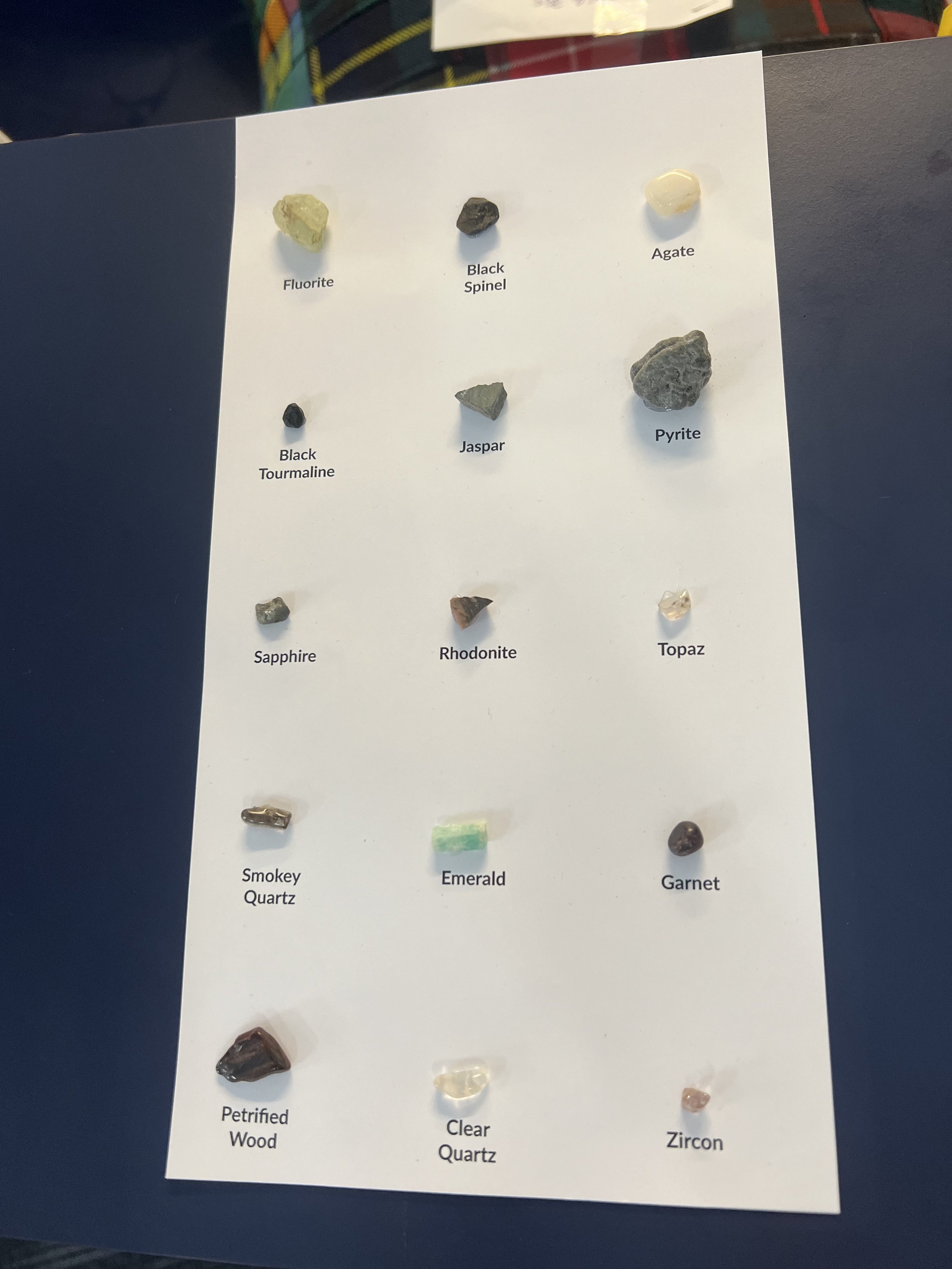
Sample of gemstones found in the Glen Innes region, photo taken at the Glen Innes visitor Information centre
Photo credit : Valentine McDonald
As mentioned earlier in this article, Glen Innes has its dedicated gem show, Minerama, in March, where several fossicking field trips are available.
Apart from Minerama, other festivals held in Glen Innes caught my attention : the Australian Celtic Festival in May, and the Land of the Beardie Festival in October/November each year.

Panoramic view from the Glen Innes Highlands Skywalk
Photo credit : Valentine McDonald
If you cannot attend the Australian Celtic Festival, make sure to pass by the Australian Standing Stones monument, a celebration of the connection with Scotland and Celtic heritage. Here, you will admire a three-dimensional calendar of giant standing stones that incorporates the Celtic cross and Southern Cross into its design.
Finally, there are museums worth paying a visit too, the Emmaville Mining Museum, which showcases about 4,000 mineral and gem specimens, or the Land of Beardies History House Museum, a folk museum with a substantial collection dedicated to the heritage of the Glen Innes Highlands.

Australian standing stones - Glen Innes
Photo credit : Time out website
Recommendations
Book the fossicking field trips organised by Minerama early, places are limited and fill up very fast
Plan a minimum of 2 days to visit Minerama
Stop by the Glen Innes visitor information centre where you can get a fossicking map, buy a pan kit and, browse Celtic memorabilia
Bring warm clothes, swimming clothes and boots (or wet shoes)
Have a breakfast at The Local Glen Innes
Try the super strawberry
Have an old-fashioned paper map (no GPS within 5 min radius of Glen Innes)
View the Australian Standing Stones at the golden hour for breathtaking photographs
Have fun fossicking and try as many field locations as possible

Mural at The local Glen Innes
Photo credit : Valentine McDonald
A special thank you to Dr Boris Chauviré (co-founder of Geogems.fr, a French-based gemmology company) for reviewing the geology section of this article.
References
Field Conference New England Area, Geological Society of Australia (GSA) Field Guide, june 15-17, 1974
1992 Field conference, Regional and Economic geology of the New England District, Geological Society of Australia, Queensland Division, Brisbane, edited by W. F. Willmott.
Quarterly Notes, 3, Geological survey of New South Wales, 1st April 1971, Department of Mines, Source of Sapphires in the New England District, NSW by A. A. MacNevin
Quarterly Notes, 94, Jan 1994, Geological survey of New South Wales, Subduction diamonds in New South Wales : implications for exploration in Eastern Australia, L. M. Barron, S. R. Lishmund, G. M. Oakes and B. J. Barron,
Tectonic cycles of the New England Orogen, eastern Australia : A review, K. Jessop, N. R. Daczko & S. Piazolo, Australian Journal of Earth Science, 2019
The geology of Australia, Chapter 5, the New England Orogen, 2016
Ultrahigh pressure macro diamonds from Copeton (New South Wales, Australia), based on Raman spectroscopy of inclusions, L.M. Barron, B.J. Barron, T.P. Mernagh, W.D. Birch, Ore Geology Reviews 34 (2008) 76–86
Mining history of the New England region, K. G. McQueen, june 2018
1972. Glen Innes 1:100 000 topographic map. Record 9238. Geoscience Australia, Canberra. https://pid.geoscience.gov.au/dataset/ga/47080
Chapter 13, The New England Tableland Bioregion, their biodiversity, conservation and history. Environment and heritage.
https://environment.nsw.gov.au/resources/nature/newenglandtableland
Prospecting of the Glen Innes Region, New techniques, new mineral systems and new Ideas, Greg Partington, Roger Mustard, Glen Little and Chris Bowden.
Australian dictionary of biography, Archibald Clunes Innes, E. Flower.
Primary Health Network, about Glen Innes, april 2024
Bureau of Meteorology website – bom.gov.au
Unesco, Australia - https://whc.unesco.org
Evening News , wednesday, July 7 1904, page 7, Australian Diamonds - The copeton field - trove.nla.gov.au
Minerama - minerama.com.au
Mindat.org - Glen Innes
Glen Innes visitor information centre - gleninneshighlands.com
Emmaville mining museum - visit NSW.com
A Proposed Aspiring UNESCO Global Geopark Nomination for the NENW Region, Margot Davis,
An eclogite-bearing breccia from the Bingera diamond field, Georges W, Records of the geological survey of New South Wales, vol VII. J, March 1902, part 2
Chapter 12, Bengonaway, Boggy Camp and Bora Creek, diamond and silver mining - library.inverell.nsw.gov.au